| The Wyre Estuary Country Park | |||||||||||
|
Introduction
In particular the fine riverside path offers excellent views over the estuary. For bird watchers there is a bird hide and a slipway for those keen to be out on the water. Special attention has been made to ensure that the Country Park is welcoming for all its' visitors, including those with special needs, and we are proud to hold the "B.T. Countryside Access for All" national award. This means that wherever possible the facilities have been designed to cater for visitors of all abilities. The Visitor Centre is accessible for wheelchair users with
lowered counters and shelves and there is ample parking space and
toilet facilities on site. There are level surfaced paths and
picnic tables around the country park and these are ideal for
people with wheelchairs or pushchairs. For blind or partially
sighted visitors there is a three-quarter mile circular trail
with tapping rail and an accompanying self guided tape which can
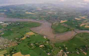
be hired from the Centre. For further details about any of these facilities contact the centre. Tel: 01253 857890. History of the EstuaryThe land surrounding the estuary was formed during the great ice age some 50,000 years ago when vast glaciers, created in the mountains of the Lake District, moved across Morecambe Bay and over the Fylde plain. As the glaciers melted they deposited debris known as boulder clay, which were then sculptured and smoothed into rounded hills called drumlins an example of which can be found at Stanah. The River Wyre is 52km long from it's source to the sea, and is the third largest river in Lancashire after the Ribble and the Lune. It has two sources one which rises on Tarnbrook and the other on Marshaw Fell high up in the Bowland Fells. Just beyond Garstang the river is joined by the River Calder and at St. Michaels by the River Brock. St. Michaels on Wyre marks the tidal range of the River Wyre. The demise of Skippool as a busy port came with the arrival of the railway to Fleetwood in 1840, and the building of new harbours which were more suitable for large ships. Cockle HallCockle Hall was once the former site of a tiny cottage which, in the late 19th century, housed a family of thirteen. One of the owners was responsible for planting the damson trees which are still visible nearby. Other residents would have collected cockles and mussels in the estuary.
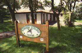
StanahThe focal point of the Wyre Estuary Country Park is Stanah with the Wyreside Ecology Centre, car park and picnic sites. However it was only 1989 when the creation and development of the Country Park began. The site had formerly been used as a rough open car park and previous to this the once marshy ground had been exploited as a refuse tip. Considerable work was carried out in shaping and landscaping the site, including extensive tree and shrub planting, footpath improvements and the creation of picnic areas to produce the park you see today. A regular bus service to Cleveleys runs to and from the car park. I.C.I. & the Salt IndustryThe discovery of vast deposits of rock salt below Preesall in the 19th Century led to the founding of a major salt industry on the banks of the Wyre estuary at Fleetwood, and the eventual development of I.C.I. Hillhouse International which can be seen today. In 1890 natural brine was pumped across the river to the Fleetwood Salt Works, and by 1892 the first brine wells were drilled. Fresh water was pumped down the bore holes to dissolve the rock salt and the resulting brine w as brought up to the surface. This was pumped across the river where it was used in the production of chlorine. A number of old brine wells are still visible around the Wyre. Mining of rock salt began in 1893 with skilled miners coming from Cheshire, and by 1906 production had reached 140,000 tonnes. The rock salt was transported by rail to a jetty by the river and loaded onto ships for export. The village of Preesall in Over Wyre made national headlines in 1923, when 5 acres of farm land vanished into a reservoir of brine almost overnight. Serious flooding of the brine wells became a problem and the mines were eventually abandoned in 1930. Further developments on site led to the founding of Imperial Chemical Industries, now commonly known as I.C.I. In 1941 I.C.I. became agents for the Ministry of Supply and started the manufacture of chemicals at the Hillhouse Works for materials required for the war effort. Since the war, many changes have taken place and the Hillhouse site now produces a range of materials and products used by millions of people throughout the world. Shard Bridge'Shard' means the narrow part of the river and a crossing has
been in existence here for approximately 2500 years. A tribe of
Ancient Britons are thought to have made the first crude
fording-place about 400 years BC The Wyreside Ecology Centre
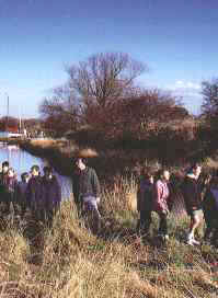
The Ranger Service also undertake a wide variety of activities with schools, youth groups and societies, as well as looking after the day to day management of the park.
Public Toilets including facilities for the less abled are open daily from 8.00am to dusk. Where to walkThere are a number of excellent paths and walks to explore within the Country Park along the estuary between Fleetwood and Skippool. Here are some suggestions:
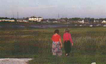
Water Sports FacilitiesBoat launching facilities are provided at both Stanah and Knott End into the Wyre Estuary. Stanah has a free public slipway. There is a charge to launch boats at Knott End. Private facilities can also be found at Skippool and Wardleys. BirdsThe Wyre Estuary forms the southern boundary of Morecambe Bay, one of the most important sites for wildfowl and waders in Europe with eleven species occurring in internationally important numbers. In addition four species; Pink-footed Goose, Teal, Black-tailed Godwit and Redshank have populations of national importance within the Wyre Estuary. Wader and wildfowl populations change dramatically with the seasons, providing a year round interest for birdwatchers. In winter large flocks of Lapwing, Golden Plover, Curlew and Redshank feed on the mudflats between Stanah and Skippool. These are joined by flocks of wildfowl including large numbers of Pink-footed Geese and Teal with smaller numbers of Mallard, Wigeon and Shelduck. They are best seen at low water on Burrow's Marsh from the riverside footpath beside the I.C.I. works. In spring, the last of the winter birds are joined by Dunlin, Ringed Plover, Sanderling and Black-tailed Godwit as they migrate to their northern breeding grounds. June and July see the return of British breeding Lapwing and Curlew to the estuary. Autumn migration begins in late July with numbers of waders increasing through August and September before many of the birds move on to the wintering areas in West Africa. This is the best time of year to see less common species such as Whimbrel, Greenshank, Spotted Redshank and Ruff, which can be found in the muddier parts of the estuary around Skippool. By late September the wintering species begin to arrive and numbers increase through October to November. Wildfowl and waders are not the only birds that use the estuary. Grey Heron, Cormorant and huge numbers of Gulls are, frequently seen. Flocks of Starlings, Skylarks and Finches winter on the salt marshes, these in turn attract birds of prey such as Kestrel, Merlin, Sparrowhawk and Short-eared Owl. The hedgerows along the river provide nesting and feeding cover for a variety of commoner species, autumn berries attract flocks of Redwing and Fieldfare newly arrived from Scandinavia. The river lies across the migration route of small song birds and on fine mornings in Spring and Autumn, the birds can be seen feeding before setting out on their journey northwards. The Wyreside Bird HideThe hide is ideally situated overlooking the bird rich salt marshes and mudflats of the Wyre Estuary. The fenced area around the hide has been landscaped to help create new wildlife habitats and both the hide and footpath leading to it have been specially adapted to be suitable for wheelchair users. Keys to the hide are available from the Wyresdale Ecology Centre during opening hours, and regular visitors may wish to take advantage of a season ticket which allows access to the hide at all times. Details of the scheme are available from the Centre. Wild FlowersThe Wyre estuary contains the largest area of ungrazed salt marsh in North West England, and is nationally important for providing food and shelter for a wide range of insects and birds. The plants are specially adapted to tolerate immersion in salt water and have waxy outer surfaces similar to cacti. Salt marsh plants grow in distinct bands with pioneer species growing on the mud, and less salt tolerant species on the highest parts of the marsh. The finest examples of salt marsh flora are found on the Burrow's Marsh nature reserve and along the riverside path between Stanah and Skippool. Plants to look for include Glasswort. Seablite, Sea Purslane, Sea Aster, Sea Lavender, Sea Milkwort, Scurvy-grass, Sea Plantain, Sea Arrow Grass and Frosted Orache. Some of the higher marshes are colonised by Common Reed with the thicker stands providing nest sites for Reed and Sedge Warbler and Reed Bunting. Visitors to the park are advised to resist the temptation to pick the Sea Lavender and Common Reed. The riverside footpath beside the I.C.I. Works has an interesting flora with some limestone plants able to exist on the infilled sea defence. Some of the special plants seen include Bee Orchid, Northern Marsh Orchid and Yellow-Wort. The short turf and patches of Birds-foot Trefoil provide suitable habitat for the Common Blue Butterfly. The hedgerows and woodland around Cockle Hall contain some attractive plants, including Red Campion, Herb Robert, Bluebells, Ramsons and Comfrey. In late summer, look out for the large dragonfly, Aeshna grandis or Brown Hawker as it hunts along the hedgerow - it is our only dragonfly with brown wings.
|